Locality „Na Špitálkách“ in Staré Město
The locality „Špitálky“, situated on so-called Velehrad promontory and forming the whole south-west part of Staré Město, was given its name after 1918. The northern part of „Špitálky“ is what is today called „Na Špitálkách“ (church foundations were found here in 1949). Velehrad promontory was already inhabited in paleolithic as we can see from the finds of paleolithic flintstone tools, sharpened and smoothed tools of linear ceramic culture, Moravian decorated culture, ceramics finds from Únětice culture period, Middle Danube barrow culture and urn field culture including the period of Hallstatt.
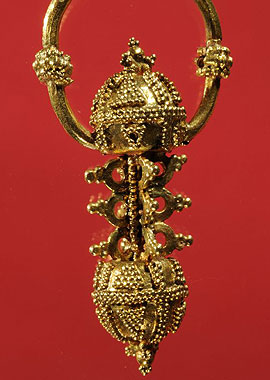
While mining gravel from a terrace on the right side of a blind arm of the Morava river in the locality of „U Stohu“, right behind the Staré Město sugar factory, workers dug to pieces 3 skeleton graves without alms in 1949. Shortly, during machinery mining a few more skeleton graves with alms were destroyed plus the entire southern half of the foundations of a Great Moravia church. In the same year a rescue research was carried out under the supervision of J. Poulík of the Brno Archaeologic Insitution of Czech Academy of Science. Discovered were another 38 skeleton graves with rich equipment (spurs, iron knives, silver and gold earrings and ball buttons, coffin ironwork, a beaten relief of a rider and a falcon beaten on a circular plaque etc.). According to the remains of the foundations the church had a rectangular nave, on the east part closed with a semi-circular apsis and on the west passed into a nartex. Its interior was divided into segments by six supports. Near the north-east corner of the church were found residues of a small object with a depression, perhaps a baptistery. A similar depression was also discovered near the south-west corner of the nartex. The church was 18.5 m long and about 8 metres wide. Its basic masonry is only preserved in negative. Along the south and west side of the church were uncovered holes from poles and traces of a wooden barrier. Indeed, it occupied a strategic position, near the road and the gate of so-called outer fortification. Given the absence of finds typical of the second half of 10th century it obviously decayed immediately after the decline of Great Moravia.
 RSS akce


